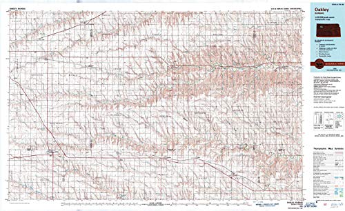
USGS topographic map of Oakley, Kansas, dated 1985, updated 1989.Includes geographic coordinates (latitude and longitude), lines of elevation, bodies of water, roads, and more. This topo quad is suitable for recreational, outdoor uses, office applications, or wall map framing.Printed on-demand by YellowMaps on the print material of your choice.Shipping rolled from Minneapolis, MN, United States.Product Number: USGS-5972842Map Size: 24.51 inches high x 40.03 inches wideMap Scale: 1:100000Map Type: POD USGS Topographic MapMap Series: HTMCMap Version: HistoricalCell ID: 68073Scan ID: 512918Imprint Year: 1989Woodland Tint: YesPhoto Inspection Year: 1987Aerial Photo Year: 1981Edit Year: 1985Datum: NAD27Map Projection: Universal Transverse MercatorMap published by United States Geological SurveyMap Language: EnglishScanner Resolution: 508 dpiMap Cell Name: OakleyGrid size: 30 X 60 MinuteDate on map: 1985Geographical region: Kansas, United StatesNorthern map edge Latitude: 39.5°Southern map edge Latitude: 39°Western map edge Longitude: -101°Eastern map edge Longitude: -100°Surrounding map sheets (copy & paste the Product No. in the search bar):North: USGS-5278338,USGS-5972854,USGS-5274996,USGS-5969584East: USGS-5969890,USGS-5277680,USGS-5974148,USGS-5971530,USGS-5969892South: USGS-5971460,USGS-5971462,USGS-5970778West: USGS-5971180,USGS-5972620,USGS-5971182
Trustpilot
1 month ago
2 months ago
