Description
- Map Size: 18 inches x 24 inches | Ready To Frame | Real Canvas Map | Archival Quality Reproduction on Fine Art Canvas | Satisfaction Guaranteed |
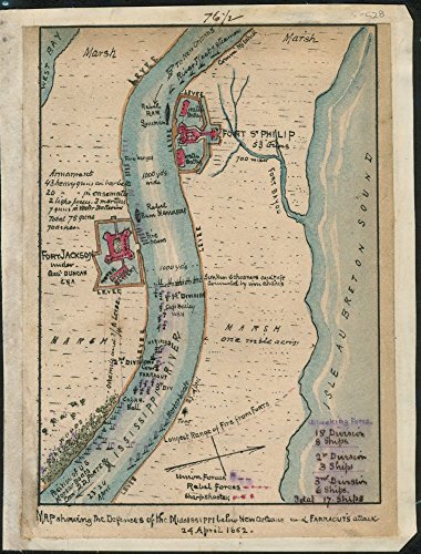
- Description: 1862 map showing the defenses of the Mississippi below New Orleans and Farragut's attack 24 April 1862. Map shows the Confederate fortifications at Fort Jackson under Gen. Duncan, Fort St. Philip and the Union fleet along the Mississippi River. This map, also shows the positions of Union ships under Farragut, who captured the strategic port of New Orleans, thereby providing the Federal army access to the Mississippi River.
- Map Subjects: Capture | Civil War | Farragut | David Glasgow | Fort Jackson La | Fort Jackson Region | History | Louisiana | Naval Operations | New Orleans | New Orleans La | Siege |
1862 map showing the defenses of the Mississippi below New Orleans and Farragut's attack 24 April 1862. Map shows the Confederate fortifications at Fort Jackson under Gen. Duncan, Fort St. Philip and the Union fleet along the Mississippi River. This map, also shows the positions of Union ships under Farragut, who captured the strategic port of New Orleans, thereby providing the Federal army access to the Mississippi River.