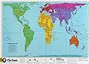
PETERS WORLD MAP, LAMINATED
Desertcart purchases this item on your behalf and handles shipping, customs, and support to Belgium.
Description
A map which shows countries in their true perspective. This also means that the equator is placed in the middle, instead of the usual allocation of 2/3 of the map to the northern hemisphere, and only 1/3 to the southern hemisphere.
Specifications
| Dimensions | 0.03 x 59.69 x 85.09 cm |
| Edition | International ed. |
| Isbn 10 | 1869847024 |
| Isbn 13 | 978-1869847029 |
| Item Weight | 227 g |
| Language | English |
| Print Length | 1 pages |
| Publication Date | 1 Aug. 2003 |
| Publisher | NEW INTERNATIONALIST |
Reviews
User
Great map
Great quality and size, every home needs this map.
User
Kids love it
The kids love it and I love how it’s the most accurate in regard to size of continents
User
Everybody should have this map, not another.
A real map I had on my wall and people kept asking me for (people is not familiarised with Peter’s map) so I bought it for a friend. He is soooo happy being able to explain to people that sees it strange why.
User
Bought it twice
Love this map. Donated one to a school in Kashmir. So had to get a replacement for myself. Arrived very quickly. Well packed. Highly recommended.
User
Big and shiny
Great map, good for doing geography with the kids, just wish it had time zones.
User
Look at the world a different way!
I first heard about this map after watching The West Wing. I love it. It is really good quality and really makes you think about the size of the country’s in the world. It is now hanging in my hallway
User
Far more than what you pay for!
I like the large size, it’s laminated and looks great on my study wall. Excellent value but I would have been happy to pay more because of the quality.
User
Brilliant
My son adores maps and I felt it was important for him to know the countries by proportional size in relation to each other and not just from a colonial perspective.
User
Recomendable
Se lee perfectamente. Buena resolución. Viene plastificado y bien envuelto
User
Magnifique!
J'adore! Elle est immense, plastifiée, bien imprimée et parfaitement lisible!Dessous la carte il y a des explications qui vous en apprennent un peu plus sur l'intérêt de cette carte et en quoi elle donne une vision plus juste du monde.Même pour ceux qui ne parlent pas anglais, hormis le petit texte en dessous de la carte qui est certes intéressant mais que vous pouvez trouver sur internet en français, la carte est parfaitement lisible et compréhensible pour n'importe qui. Il serait dommage de vous en passer juste parce que le nom des pays est en anglais!Bref, ravis de cette magnifique carte du monde!
User
excellent map
I have ordered the same map from other companies & was very disappointed. They BAREY made any distinction between the Mercader map and the Peterson. This map is visually appealing. Presented in schools along side the Mercader would encourage discussion of world history. Many adults, I've met don't understanding the significance of the map as it relates to present world view. It is for that reason that it is imperative to introduce diverse views in schools. We shouldn't complain about the apathy of the young, when we don't engage them early on, about real civics.
User
Ottima per studiare
Completa di plastificazione
User
Gute Weltkarte
Die Weltkarte war für die Kinder, um Länder und Orte auf unserem Globus besser kennenzulernen.Die Karte ist gut gedruckt und hält auch nach einem halben Jahr Kinderhände sehr gut. Ich bin zufrieden und habe auch keine Verbesserungsvorschläge.
Common Questions
Trustpilot