
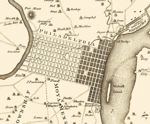
PHILADELPHIA PENNSYLVANIA (PA) CITY & ENVIRONS MAP 1777This is an exquisite full-color Reproduction printed on Matte Art Paper. These maps are perfect for framing, or a wonderful and unique gift for family members, friends or co-workers!All Information is Carefully Compiled from Actual SurveysOriginal Maps are often difficult to find and usually have fold lines, identifying stamps or markings, tears, ragged edges, and assorted other natural signs of age that detract from their beauty. All of our maps have been professionally restored to depict their original beauty, while keeping all historical data intact.These maps are fabulous pieces of history full of information useful to Historians, Genealogists, Cartographers, Relic Hunters, & Others. They make fascinating conversation pieces and splendid works of art for the home or office.Print Size: 23.00 x 30.66 inchesSites and Townships Specific To This Map Are: A Table of the Distances of the Most Remarkable Places, Fair Mount, Road to Burlington, Road to Lancaster, Road to Bristol and Trenton, Road from Wissahicoon, Schuylkill River, Point of no Point, Richmond, Gunner's Run, Cob Creek, Delaware River, Hollanders Creek, Coultis's Saw Mill, Schools, Churches, and other Prominent Buildings, Shultz's Paper Mill, Merrion Meeting, Governor Penns, Windmill Island, Billingsfort, Snuff Mill & Sugar House.The following towns are featured: Germantown, Philadelphia, Frankfort, Kensington & Gloucester.This Map is Situated in: Philadelphia (Independence City), Pennsylvania.SKU: PAPH0001-3
Trustpilot
5 days ago
2 months ago
