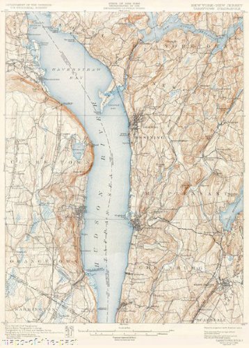
TARRYTOWN QUAD NEW YORK (NY/NJ) USGS 1902This is an exquisite full-color Reproduction printed on Matte Art Paper. These maps are perfect for framing, or a wonderful and unique gift for family members, friends or co-workers!All Information is Carefully Compiled from Actual SurveysOriginal Maps are often difficult to find and usually have fold lines, identifying stamps or markings, tears, ragged edges, and assorted other natural signs of age that detract from their beauty. All of our maps have been professionally restored to depict their original beauty, while keeping all historical data intact.These maps are fabulous pieces of history full of information useful to Historians, Genealogists, Cartographers, Relic Hunters, & Others. They make fascinating conversation pieces and splendid works of art for the home or office.Print Size: 23.00 x 29.92 inchesSites and Townships Specific To This Map Are: Sarles Hill, Buttermilk Hill, Chappaqua Hill, Haverstraw Bay, High Tor, Salt Hill, New York Central & Hudson River Railroad, Erie Railroad, Northern Railroad of New Jersey (Piermont Branch), Sparkill, Havensack River, Sawmill River, Dobbs Ferry, Croton Bay, Hudson River, Rockland Lake, Kingsland Point, Walberg Landing, Toms Brook, Quaker Bridge and State Prison.The following towns are featured: Ossining, White Plains, Haverstraw, Congers, Croton, Tarrytown, West Nyack and Tappan.This Map is Situated in: Westchester and Rockland Counties, New York (NY) and New Jersey (NJ)SKU: NYTA0001-3
Trustpilot
5 days ago
2 weeks ago
