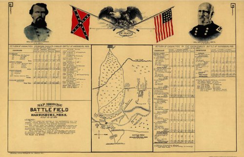
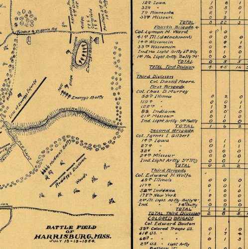
HARRISBURG BATTLEFIELD MISSISSIPPI (MS) CIVIL WAR MAP 1864This is an exquisite full-color Reproduction printed on Matte Art Paper. These maps are perfect for framing, or a wonderful and unique gift for family members, friends or co-workers!All Information is Carefully Compiled from Actual SurveysOriginal Maps are often difficult to find and usually have fold lines, identifying stamps or markings, tears, ragged edges, and assorted other natural signs of age that detract from their beauty. All of our maps have been professionally restored to depict their original beauty, while keeping all historical data intact.These maps are fabulous pieces of history full of information useful to Historians, Genealogists, Cartographers, Relic Hunters, & Others. They make fascinating conversation pieces and splendid works of art for the home or office.Print Size: 23.00 x 35.81 inchesSites and Townships Specific To This Map Are: This map shows the position of the confederate and the federal forces during the three day encounter, showing in detail the position of several commands. The table shows the record of casualties in offices and men killed, wounded, or captured during the three days as compiled from official records of the union & confederate armies. Small Rayine, Tupelo & Verona Road, Tupelo & Pontotoc Road, King creek.The following towns are featured: Harrisburg, Tupelo.This Map is Situated in: Dauphin County, Mississippi.SKU: CWHA0001-3
Trustpilot
2 weeks ago
2 weeks ago
